ArcGIS Collector: Update Error Code 1006
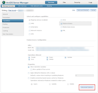
Alright, this is the second time this happened to me, and I neglected to document it the first time, so I had to search again to find the answer, so I will document it here, and now. Here goes... If you happen to come across ArcGIS Collector throwing an error when updating a feature, and the error states something along the lines of: Invalid untrusted Html content detected in field: Have no fear, there is a simple fix. Well, that is, it's a simple fix if this is 'local' map, not accessible to the general public. That's only because ESRI doesn't actually 'recommend' this fix. So what is 'this fix' I speak of? A little more background... If you have any fields that contain HTML content, there is a chance that Collector could see that as malicious content, and it will block it. You can see a list of allowable HTML tags in Collector a this link . In my instance, I am running some database triggers to populate and update a URL field, where


